Nepal's Oldest Himalayan Buddhist temple and monastery threatened by Floods.
For years I had heard of the existence of a fabulous Rinchen Zangpo-period (late 10th - early 11th c.) Buddhist monastery in Halji village in the Limi valley, one of the most remote regions of the Nepal Himalaya, far up in the NW corner of the country, just below Mt Kailash. I had a chance to find out more through my old friend Mimi Church who had been there several times on her way to or from Western Tibet and the mysteries there.
Asianart.com published her report in October of 2008: A four-fold Vairocana in the Rinchen Zangpo tradition at Halji in Nepal.
In November of last year my wife Lois and I and a sculptor friend, Mary Shaffer, had the chance to go to the Limi valley with Astrid Hovden, Norwegian PhD candidate who has been studying the culture, religion and language of the Limi valley for the past two years. She was an incredible guide to this fabulous place, and introduced us to the people and culture of the valley. When we left Limi and continued on to the Tibet border, where we crossed over and drove through Western Tibet and on to Lhasa, we left Astrid in the valley, where she spent the entire winter, only coming out in May.
While we were there we found out a lot more about the terrible danger that threatens the ancient monastery of Rinchen Ling and the village of Halji where it is situated. Each summer for the last several years, usually at the end of June, the village suffers from a Glacial Lake Outburst Flood, (GLOF), which storms down from the glaciers and tears at the embankments set up by the villagers over the previous months. Year by year the floods take away more land, destroy more fields, and come ever closer to the ancient monastery.
Below we present Astrid's eyewitness account of the flood of late June 2011.
Led by Astrid Hovden, a group of people who want to help preserve this ancient village and temple have mobilized to find support for this effort. The Mountain Institute (TMI) has joined this effort: Brian Peniston, TMI Director of Himalayan Programs has crafted a grant proposal and requests have been made to two foundations in the hopes that they may be able to support the protection of Halji and the gompa.
In the links above you will find a direct link to the TMI donation page for those who would like to help with the effort to save the village and ancient gompa of Halji.
Ian Alsop, editor, asianart.com June 17 2012.
Glacial Lake Outburst Flood in Halji, Limi VDC 30 June 2011
An eyewitnness account by Astrid Hovden,
PhD fellow at the University of Oslo, Norway
July 16, 2012
(click on the small image for full screen image with captions)
all images © Astrid Hovden
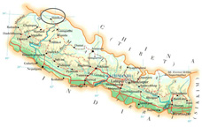
Fig. 1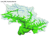
Fig. 2With about 400 inhabitants, Halji is the most populous village in Limi VDC of Humla district in north western Nepal. The village is situated at an altitude of 3650 metres on the northern banks of the Limi River, a tributary to the Karnali.
Halji village is constructed around the 11th century Rinchenling Monastery, the oldest Tibetan Buddhist monastery in Nepal and a potential World Heritage Site.
Since 2006 the monastery and the village has been threatened by flash floods caused by the overflow of a glacial lake. The last flood struck the village in the afternoon of June 30th 2011.
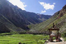 Fig. 3 |
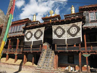 Fig. 4 |
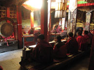 Fig. 5 |
Account of the flood
The flood started around 4:30 pm.
In the beginning the water was retained by the gabion walls, the last stretch of which was built only a month earlier. But as the flood grew fiercer, the embankments burst and water gushed towards the village with great force.
 Fig. 6 |
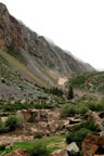 Fig. 7 |
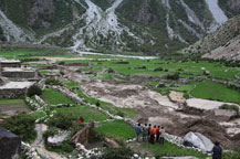 Fig. 8 |
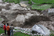 Fig. 9 |
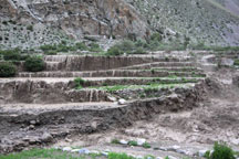
Fig. 10The ground was shaking as the water carried a large amount of rocks and debris. The rocks made the water change its course several times, and chunks of land kept sliding down on both sides of the valley colouring the water almost black and filling the air with a strong smell of mud.
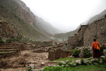
Fig. 11People immediately started evacuating the houses near the river bank and managed to move most of their belongings to the houses of relatives further away. After a while it became too dangerous to enter the houses and people could only passively watch the river carving its way towards the western walls of their houses.
At around 7:30 pm, the first wall gave in, and an hour and a half later two houses were cut open by the flood. People were crying as they witnessed their fields and homes being gradually carried away by the torrents of water.
By 10 pm in the evening, the flood slowly started to recede, and by the next morning, the water level was down to normal.
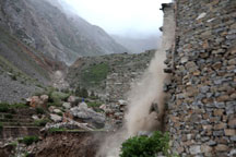 Fig. 12 |
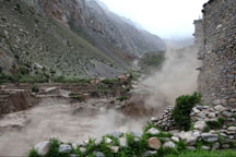 Fig. 13 |
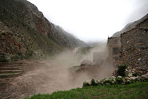 Fig. 14 |
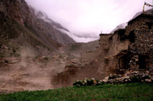 Fig. 15 |
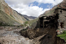
Fig. 16Two houses belonging to Mr. Tsering Ngodrup Tamang and Mr. Sonam Gyaltsen Tamang, which were situated near the river bank, were completely destroyed by the flood.
In addition, the families living in the five directly adjoining houses will have to rebuild their houses.
The flooding river has carved out much of the moraine ground on which the village is built, and twelve houses and the one thousand year old monastery which is now located only a few metres from the river bank are at great risk.
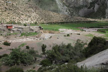
Fig. 17Four officers from the local police force stationed in Sunkhani visited the site of the disaster the day after the flooding and estimated that approximately 200 ropanies of land were destroyed that evening.
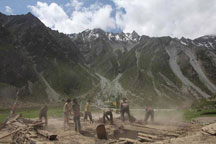
Fig. 18Since the flooding started in 2006 more than 100 fields have been washed away and another 100 fields were completely covered by sand and rendered useless by the recent flood. Some of the livestock is reported missing after the flood and a few of the families have lost all their fields. Food aid will therefore be needed for the winter.
Water mills and important infrastructure like bridges and sections of the main road through the valley were also washed away, and virtually the whole path at the bank of the flooding river leading up to their pastures in a neighbouring valley was completely flooded.
Glacial Lake Outburst Flood (GLOF)
The cause of the flood is the outburst of a glacial lake, a so called GLOF, in the mountains above Halji village. The flood has occurred at almost the same date at the end of June every year since 2006, with the exception of 2010. Three teams of local villagers (including the author of this report) have climbed up to the glacier to find the source of the flood.
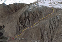 Fig. 19 |
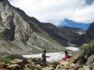 Fig. 20 |
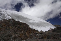 Fig. 21 |
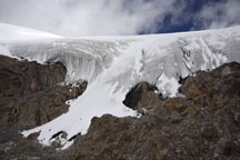 Fig. 22 |
In front of the glacier (covering a plateau at an altitude of 5200-5400 metres) are four glacial lakes, all of which feed into the flooding river.
However, the main source of the flood is a sub glacial lake, partly visible from a deep crevasse located at an altitude of 5300 metres. According to a team of villagers who climbed the glacier just after the flood in 2009, the lake was partly covered by a big ice sheet, about 20-25 meters thick. Ice sheets must have broken off and fallen into the lake, discharging huge amounts of water, leaving a wide scar all the way down to the village.
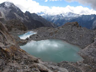 Fig. 23 |
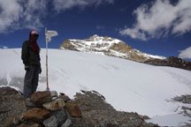 Fig. 24 |
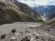 Fig. 25 |
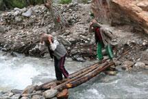
Fig. 26
The Nepali government provided some support for the building of gabion walls in 2010 and 2011. For the support given, local villagers built walls at the side of the village, which helped retaining the water for some time, but the embankments were too short and too low to hold against the currents when the river grew bigger in the evening.
After the recent flood, the district authorities have also allocated rice and money for buying kitchen utensils to the two families who lost their houses. However, seven families will have to build new houses this winter and more funding is needed.
What can be done?
In order to estimate the risks for future outbursts of the lake and resulting impacts, an expert team consisting of a hydrologist, a glaciologist and an engineer should be mobilized and sent up to the glacier. The expert team should produce a detailed technical report assessing the risk for further flooding and develop long term strategies to minimize the risks of a future disaster. Long term mitigation strategies may involve the digging of a canal enforced with embankments to divert the flood away from the village and monastery, and if possible, controlled drainage of the lake.
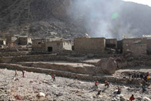 Fig. 27 |
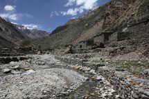 Fig. 28 |